
Oak Ridge Neighbors Around One Block
A block search is narrower than a full street search. It begins with a target parcel and uses the records that describe surrounding land, recorded ownership, and public community resources. The table separates what a source can actually establish from what it cannot. A public owner or transaction party is a record clue, not a complete account of who is currently present at a nearby address.
| Block source | What it adds around an address | Access path and limit |
|---|---|---|
| Anderson GIS | Parcel polygons, property context, zoning, boundaries, and adjacent shapes | Online viewer; exact live map tools were not captured |
| Roane GIS GeoHub | Parcels, aerial imagery, property details, and location datasets | Online map; verify informational GIS data with the office |
| TPAD or assessor roll | Tax owner, mailing address, situs, assessment, and parcel reference | Free state search; county must be chosen |
| Recorded deed index | Transaction parties and legal description for nearby parcels | Anderson online from 1990; Roane subscription or office route |
| Oak Ridge tax and CityView | Municipal account or public address/project clue | Online tax search plus address, Parcel ID, application, or project routes |
| Criss-cross and city organization directories | Historical address clue or public civic contact | Library verification for historical volumes; city list has public filters |
For Oak Ridge neighbors, the county choice comes first. The city crosses Anderson and Roane counties, so an address can share the Oak Ridge name while relying on a different assessor, GIS viewer, recorder, and election office than a nearby address on the other side of the line.
When an online screen does not expose an older municipal file, begin with the City Clerk or Planning and Development rather than guessing from a missing result. The clerk is the custodian for city legislative records and receives Tennessee Public Records Act requests. Tennessee citizens have the statutory right to inspect existing public records; an inspection-only request does not require a written form. Oak Ridge also provides an open-records form for copies, electronic delivery, mail, or pickup when a specific existing city record is needed.
Map an Oak Ridge Block Parcel by Parcel
Use the GIS map to establish the physical relationship among lots, not to assume a household relationship. Anderson identifies property, zoning, and boundary information in its mapping layer. Roane identifies parcel boundaries, property details, aerial imagery, and location datasets. Look at both sides of the road and behind the target lot. An apparent neighbor can be separated by a creek, road, easement, or mapped boundary.
- Center Anderson or Roane GIS on the target address and select or identify its parcel.
- Follow the lot boundaries outward, recording each adjacent parcel ID, county, road context, and subdivision or lot information.
- Open the matching TPAD or county assessor record for each parcel. Compare the situs, mailing address, tax owner, and parcel identifiers without treating the mailing address as a residence claim.
- Use the legal description to check a nearby recorded deed when an ownership change or older transaction matters.
The exact buffer, measurement, export, and live adjacent-click controls were not exposed in the inspected map text. For a full named-street record chain, use the Oak Ridge street directory after the immediate block has been mapped.
Check Oak Ridge Parcel Records
After the map supplies a parcel ID, TPAD or the county assessor can provide the tax-roll owner, mailing address, situs, assessment fields, and other parcel details. Those values are useful for comparing nearby parcels, yet they do not prove a current household connection. A tax notice can go to another address, an attorney, or another property. The situs identifies the physical parcel and is the better map reference.
For a transaction check, start with the current owner as grantee in the correct county's deed index. Note the prior grantor, recording date, book/page or document number, and legal description, then compare that description to the parcel map. Anderson's online index and images are complete from January 1, 1990 to the present. Roane records date to 1801, but the official page does not give an online cutoff, so the Register of Deeds or paid service is the necessary fallback.
Oak Ridge's municipal tax search accepts an address, owner, receipt, or tax-map mode. CityView can search property by address or Parcel ID and its permit and planning locators can use address, Parcel ID, application, project number, or project name. Use those municipal sources as context for a parcel, not as a substitute for a deed or a resident list.
Plats and subdivision restrictions can resolve a block question when a deed does not use a current street number. A recorded plat establishes the layout of lots, blocks, streets, and easements. For a difficult parcel, carry the lot/block, subdivision, map/group/parcel, and legal description to the Register of Deeds or planning office. That is more reliable than matching a similar-looking address on an online map.
Find Oak Ridge Community Contacts
Public community contacts add a civic layer that parcel records do not have. Oak Ridge's organization directory reported 135 listings and provides a category dropdown, name search, and first-letter filter. An entry can show an organization name, address, telephone number, and contact person. It is a directory of organizations, not a roster of block members or a list of all neighborhood groups.
The category and A-Z controls are shown on the official Oak Ridge organization directory.
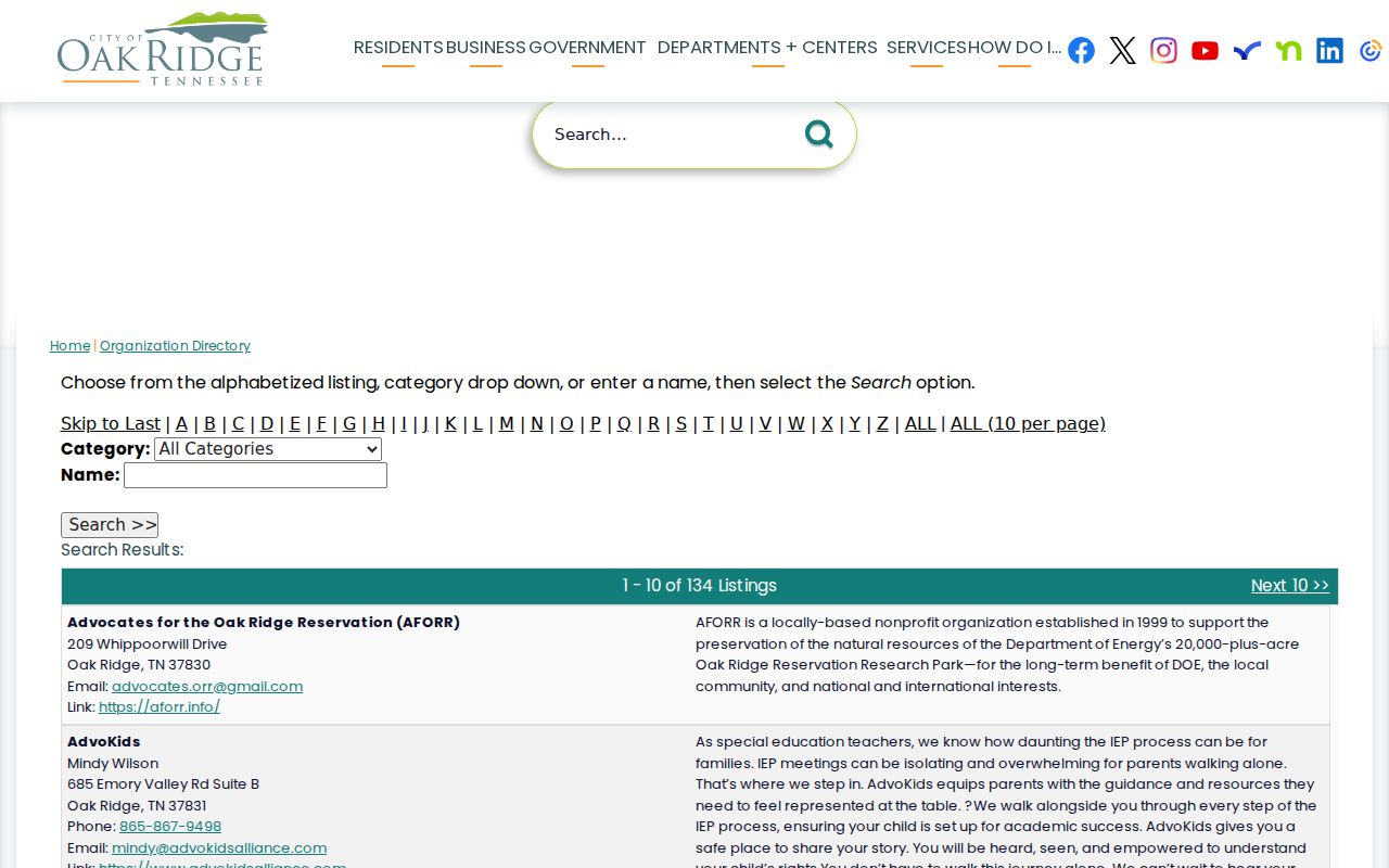
Use the published organization contact as a way to locate a public meeting or community resource. Do not infer private membership, a home address, or a block relationship from an organization listing.
Oak Ridge Neighborhood Resources
Oak Ridge planning material names local areas including Scarboro, Woodland, Highland View, and East Village. These place names can help distinguish a community context from a county record boundary, but they do not replace the county check for a parcel. The city organization directory is the current umbrella source for civic contacts. Its published listing count should not be treated as an inventory of neighborhood associations or their boundaries.
Scarboro Community Center
148 Carver Avenue, Oak Ridge, TN 37830
865-425-3950
Public facilities include a gym, kitchen, meeting rooms, game and computer lab, park courts, and playground.
Oak Ridge Chamber
1400 Oak Ridge Turnpike
865-483-1321
info@orcc.org
A community and business umbrella resource; its membership directory was not exposed in the source fetch.
An Oak Ridge Recreation and Parks meeting document reported 24 active neighborhood-watch groups in 2015. That is a historical count, not a current roster. Use a watch group or civic organization only through its published contact or meeting information.
Read Oak Ridge Voter Records Carefully
Tennessee's public voter lookup is an individual registration match, not a block-browsing tool. It requires county, first name, last name, birth month, and birth year. Select Anderson or Roane only after the address's county is established. A no-match message directs the user to verify information and contact the county election commission, not to infer that someone moved or is unregistered.
Voter records exclude Social Security, driver's-license, and DHS identification data. State law allows voter-list access subject to statutory conditions, including a political-purpose certification for a statewide list and production-cost rules. The individual lookup does not turn into a public nearby-address list, and protected voters should not be reverse-engineered from parcel clues.
The full voter file is a separate request, and the source set did not locate an Anderson County request form, current fee, delivery format, list fields, or county election-office contact page. Contact the Anderson Election Commission or the Roane election office for the current packet and permitted-use certification. A list request still does not override the statutory redactions or turn a public record into permission to publish a block roster.
Compare Oak Ridge Neighbor Sources
Official records preserve the connection to the office that created or maintains the information. A commercial neighbor-lookup category can combine parcel, directory, and marketing data, but it may merge adjacent names or retain outdated material. Use it, if at all, only as a lead to confirm with an original public source.
| Official parcel and civic sources | Commercial compiled neighbor tools |
|---|---|
| Identify a parcel, public tax owner, recorded deed party, mapped boundary, or published organization contact. | May combine material from several sources and can carry stale or merged information. |
| Provide an identifiable custodian for correction, office help, or an older-record fallback. | Are not the original custodian and do not correct a county deed, tax roll, or city record. |
| Support parcel history, genealogy, civic curiosity, and careful verification. | Need confirmation against a county parcel, deed, or publicly published civic source before a claim is relied upon. |
The best comparison is a specific one: check the parcel boundary in GIS, then the owner or situs in the assessor record, and then a deed if the issue is an ownership transaction. That sequence gives Oak Ridge neighbors a traceable record path instead of a broad unverified list.
Privacy Limits for Oak Ridge Neighbors
Public records at block scale have firm boundaries. They do not reliably identify every household member, non-owner resident, visitor, utility customer, or private organization member. DMV personal information is restricted under the federal Driver's Privacy Protection Act. Protected voter and address-confidentiality information, juvenile, sealed, and expunged court information, and confidential vital details are also outside an ordinary neighborhood search.
Lawful use. Use Oak Ridge neighbor information for personal, lawful research, community history, or a civic question. Do not use it to stalk, harass, intimidate, or harm anyone.
Tennessee Safe at Home provides a substitute government address for eligible participants. It does not erase every underlying public record, and the program's property-record exception is not a reason to expose or reconstruct a protected address. When a source contains an error, contact the original public custodian for correction.
The Tennessee Information Protection Act gives consumers certain rights against covered data controllers, including access, correction, deletion, a portable copy, and specified opt-outs. It does not require a county custodian to erase a recorded deed, tax roll, or court record. For a compiled-data error, correct the source record first, then ask any downstream service to refresh its copy.